Ali+Sacred Mountain+Sacred Lake+Guge Dynasty+Mount Everest 7 days
▍D1 day Lhasa and one day Gaze
Easy itinerary. Elevation that night: 3950m (360KM). Good road conditions. Accommodation: Thangka Hotel or similar attractions: Brahmaputra River Valley, Lhasa Valley (far view), Yamdrok Yomtso Lake, Karola Glacier, Baiju Temple (far view) )
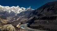
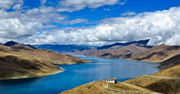
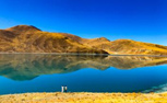
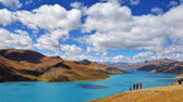
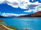
At 8:00 in the morning, we gathered at the Armed Police Border Defense Building to apply for passes. After that, we drove to start our long-awaited trip to Ali. The road conditions were very good, the entire journey was on asphalt roads, and the journey was time-limited. Climb the Gambala Snow Mountain at an altitude of 4990 meters, overlook the Gambala Radar Station, and follow the old road to the highest freshwater lake in the world. Yamdrok Yumtso Lake (the lake is 4441 meters above sea level, with a shoreline of 25 kilometers and an area of 638 square meters). km). It is called "Jasper Lake" in Tibetan and is one of the three holy lakes in Tibet (1.5 hours' drive). It is the filming location of the movie "Red River Valley". Along the way, I feel relaxed and happy. Pass by the sleeping ice beauty of Karola Glacier (about 30 minutes, crystal blue, a great work of art sculptured by time). Arrive at Langkazi County at 11:30 and have lunch here. (After dining for about an hour, drive through the heroic city of Gyantse and visit Baiju Temple (at your own expense). The Tibetan abbreviation is "Bankuo Deqing", which means "Auspicious Wheel Dalue Temple". It is a typical combination of a pagoda and a temple. It is a Tibetan Buddhist temple building with a temple within a pagoda and a pagoda within a temple. The temples and pagodas are naturally integrated and complement each other. Its architecture fully represents the typical style of temple architecture in the Tibetan area from the end of the 13th century to the middle of the 15th century. It is also the only one that has been completely preserved. Today's temples and pagodas are large-scale buildings with monumental properties, so they are called the King of Tibetan pagodas. Arrive at Xigaze Haibo (3950 meters), an important town in Tibet. On the way, you may be lucky enough to see Buddhists worshiping three steps at a time. I bowed my head devoutly on the snow-covered plateau, measured the pilgrimage road with my flesh and blood, and trudged hard towards the holy land in my heart. I arrived at around 7:30 pm and stayed in Shigatse for the night.
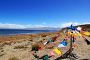
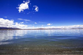
Brahmaputra River Valley:
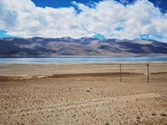
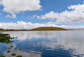
Yanghu:
Karola Glacier:
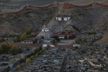
Baiju Temple:
▍D2 day Shigatse-Saga
Itinerary is easy. Elevation that night: 4700m (449km). Asphalt road. Accommodation: Yizhan Manor Oxygen Hotel or similar. Today’s highlights: Zhasi Lunbu Monastery, Langcuo Lake, Sangsang Prairie, and Sobilaya Mountain.
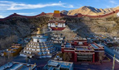
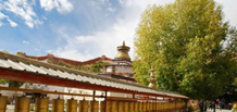
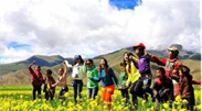
After breakfast, we first visit Tashilhunpo Temple, the residence of the Panchen Lama Living Buddhas for generations (time is about 2-2.5 hours). This temple was built in 1447 and is one of the six major temples of the Yellow Sect. On the tin floor, purple smoke rises from the incense burner in the temple, and the altar lights flicker. For more than five hundred years, it has strongly attracted Buddhist believers at home and abroad. It is a Gelug sect temple of Tibetan Buddhism in China. Located at the foot of Niseri Mountain in Shigatse, Tibet. In the twelfth year of Zhengtong in the Ming Dynasty (1447), Gendun Zhu, a disciple of Tsongkhapa, built it. The fourth Panchen Lama Lobsang Chokyi Gyaltsen expanded it. The Cuoyin Hall in the temple can accommodate 2,000 people for Buddhist scriptures. There is a statue of Buddha Yingmuni in the hall, and on both sides there are standing statues of Gendun Lord and the Fourth Panchen Lama. On both sides of the main hall are the Maitreya Hall and the Tara Hall. On the west side of the temple is the Great Maitreya Hall, which is 30 meters high and very magnificent. There is also the Pagoda Hall of the Panchen Lama, which contains the physical relics of the Panchen Lama. The temple has four zhacang (schools of sutras), which teach both sutras and esoterics. Continue driving to Lazi and Sangsang grasslands. The scenery of snow-capped mountains and grasslands along the way - bright sunshine, boundless grasslands, blossoming cattle and sheep, green tender grass, and the mysterious appearance of unknown snow-capped mountains in the distant horizon will amaze you all the way. Delightfully beautiful. Then cross the Chela Pass with an altitude of 4915M, and walk along the Duoxiong Zangbo River Valley for about 125 kilometers on Route 22, which is the branch of the Ali South Line and the North Line. The North Route is very difficult to walk, but the scenery along the way is so exciting that you will forget about it. of fatigue. On the way, we passed by the hot spring area with dense hot springs and steaming mist. Along the way, we watched the colors of the roadside lakes constantly changing. The blue, green, purple, gray, and yellow lakes looked at each other quietly, giving people an urge to linger. It is a broken lake and a saltwater lake. The lake water is green and complements the blue sky. Wild donkeys, yellow sheep, blue sheep, Tibetan antelopes, hares, yellow ducks and other wild protected animals gallop on the grassland, like a vivid classical ink painting. Stay in Saga at night.
Langcuo Lake:
Sangsang Prairie:
▍Day D3 Saga and Zhongba-Talqin (Baga)
The itinerary is easy (489km) and the road conditions are slightly smooth. Accommodation: Shanshui Oxygen Hotel or similar Haicheng Highlights today: Gongzhucuo, Yuanguan Manasarovar, Wangrenboqi (yuanguan)
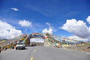
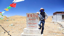
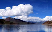
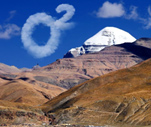
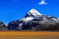
Departing from Saga at 8:30 in the morning, we headed to the Holy Mountain, Holy Lake and Ghost Lake. On the way, we saw the Lenbulugangri Mountain Peak in the distance, with an altitude of 7095 meters. We passed through Zhongba and arrived at Payang. We first visited the Holy Lake Manasarovar Lake, which has the highest water transparency in China. of freshwater lakes. It is located between the main peak of the Gangdise Mountains, Yiyiwang Rinpoqi Peak, and the Namunani Peak of the Malayan Mountains, in Purang County, Tibet Autonomous Region. Mapam Yumcuo is also called Mafamutuo, and was once called Ma Chuicuo. It was once connected to Laangcuo (Lake), and later evolved into an endorheic lake due to blockage by flood sediments and ice water accumulations. Manasarovar Lake is a freshwater lake, while Laangtso Lake is a saltwater lake. It is said that Manasarovar and Laangcuo are connected at the bottom of the lake. One side is the freshwater holy lake, and the other side is the powerful ghost lake. It can be said that Laangcuo is also an attractive landscape. At around 12:30 noon, we had lunch at Pa Yang Hotel. After the meal, we passed through Maqiao Border Inspection Station and went to Taqing, a small town under Mount Kailash Rinpo. Mount Kailash: (ticket to Holy Lake is 150 yuan, sightseeing bus is at your own expense). The main peak of Gangdise Mountains, Mount Gangrenboqi, is 6,638 meters above sea level. It is called "Shiva's paradise" in Sanskrit and means "mountain of gods" in Tibetan. The shape of Mount Gangrenboqi is similar to The pyramid (Tibetans call it the "handle of the stone mill") has four symmetrical walls. Mount Kailash is a world-recognized sacred mountain. It is also recognized as a sacred mountain by Hinduism, Tibetan Buddhism, Tibetan native religion Bon, and the ancient Sena religion. center of. Kailash is a sacred mountain recognized by the world. The mystery of the sacred mountain is that for some reason, the sunny side of the mountain is covered with snow all year round. On the other hand, the back side of the sacred mountain has no snow all year round. Even if it is covered with white snow, it will melt as soon as the sun comes out, which is contrary to the rules of nature. , stay in Tarchin at night.
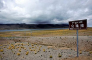
Gongzhucuo:
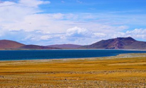
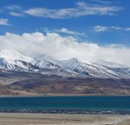
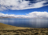
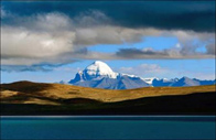
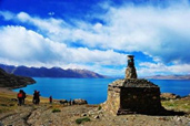
Manasarovar:
Gangrenbuche:
▍Day D4 Tarqin (Baga)-Zada-Talqin (Baga)
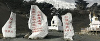
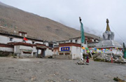
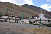
The itinerary was easy. The altitude that night was 4300m (496KM). The asphalt road was in very good condition. Accommodation: Shanshui Oxygen Hotel or similar. Today’s highlights: Wangrenboqi, Zanda Tulin, Guge Dynasty, Tuolin Temple (far view)
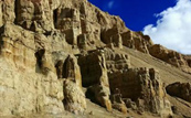
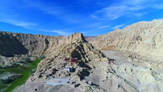
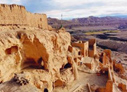
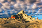
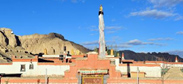
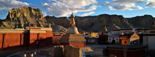
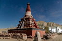
Departing from Tarqin at 8 o'clock in the morning, facing the morning glow between Mount Kailash and Namunani Peak, we walked through the soil forest to Zada to visit the ruins of the Guge Kingdom. The road conditions were difficult and part of the road was under repair. Then we arrived at Zada. After lunch, we will go to the Guge Palace (Guge Dynasty), which will make you look up at the majestic Guge Kingdom. The ruins of the Guge Kingdom are an ancient city on the plateau. The entire ruins include more than 300 houses, caves, pagodas (more than 10 meters high), and 3 temples. There are 4 buildings, 2 halls and 2 underground passages, divided into three floors: upper, middle and lower, which are palaces, temples and residential buildings in sequence. There is a city wall on the outside, and there are several towers on the four sides. The sculptures, statues and murals in its Red Temple, White Temple and Samsara Temple are outstanding. The Guge Kingdom was established around the 10th century AD by Jidenimagon, the great-grandson of the last Tushu dynasty Zampulang Dama, who fled there with his followers after the collapse of the dynasty. The Guge dynasty once had a splendid civilization history of seven hundred years, and its disappearance is still a mystery. After the tour, return to Zada County along the original road. Visit the Toling Temple, which has a history of more than 900 years. This temple combines the styles of Indian Kashmir, Ladakh and Nepal in its architectural style and Buddhist statues. It is a master of architectural and Buddhist styles from all over the world. Depart from Zada County to Zada Earth Forest, which is located in Ali Zada County. It is formed by the geological changes of ancient lake basins and river beds over millions of years. The earth forest covering a radius of nearly several hundred square kilometers is full of "forest trees" of various heights and shapes, and there are also early human cave ruins. The Zada Earth Forest covers an area of hundreds of kilometers. Its landforms are geologically called fluvial and lacustrine facies, and have a very western flavor. We will return to Talqin to check in in the evening.
Zada Tulin:
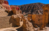

古格王朝:
Tuolin Temple:
▍D5 Tiantalqin and Zhongba--Saga
The itinerary is 4000m (468KM) to Xiaohai Tower. The asphalt road is very good. Accommodation: Yizhan Manor Oxygen Store or similar. Today’s highlights: Kailash, Manasarovar (Holy Lake), Laangcuo (Ghost Lake), Gongzhucuo
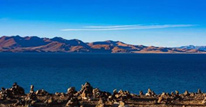
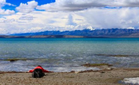
Departing from Talqin at 8 o'clock in the morning, we met the pilgrimage between Mount Kailash and Namunani Peak, and headed to Manasarovar Lapincuo to pay homage to the holy lake. Mayonco is known as the "Mother of Rivers in the World", and there is A ghost lake is called "Laang Cuo" in Tibetan, which means "poisonous black lake" and Laang Cuo is a saltwater lake. Laangcuo is a close neighbor of the Holy Lake. The scenery is equally beautiful, and the lake water is also mesmerizingly blue, but it has been labeled as a "ghost lake" and placed in a separate book. Because the color of the lake is exceptionally beautiful, some travelers like to walk to the lake to take a closer look. In fact, there is nothing near the lake. La'ang Cuo, also known as Ghost Lake, is separated from the Holy Lake by a dike. The area between the two lakes is the only way to enter and exit Pulan County. It is said that the ghost lake has three feet of waves without wind. In fact, the scenery here is very beautiful. The dark red hills beside the lake are blurred in color, and the pebble beach is like a white and bright silver belt, inlaid on the lakeside. There is also a small island in the lake, which is dark red. Then Yuanguan Gongzhucuo went to Saga to check in.
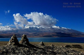
Laangcuo:
Gongzhucuo:
▍Day D6 Saga--Xixia Bangma Peak--Pefacuo--Mt. Everest Nature Reserve (Basong Village)
Easy itinerary. Elevation that night: 5190m (330km). Road conditions. Asphalt road. Accommodation: Wangsheng Oxygen Hotel or similar. Today’s highlights: Xishapangma, Mount Everest, Rongbuk Monastery, Pephatso, Xishapangma, Mount Everest, Chengbu Monastery. 214 819
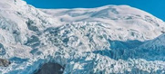
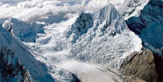
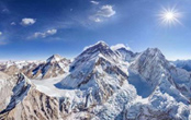
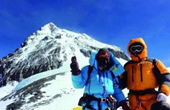
After breakfast, drive to the most impressive glacier group in the Himalayas, Shishapangma Glacier Group. Shishapangma Peak is 8,012 meters above sea level. It ranks 14th among the 14 peaks above 8,000 meters in the world. It is the only one completely in the sky. Among the 8,000-meter peaks in China, the most fascinating one is the serac area with an altitude of 5,000-5,800 meters. It is static and beautiful, like a glacier garden. Shishapangma Peak in the sun is covered with snow and is spectacular. Then drive to Pegucuo, which is the largest lake in the Shigatse region, covering an area of more than 300 square kilometers. There are various Tibetan special plateau objects on the lakeshore. Afterwards, we took a bus to Mount Everest Base Camp and took photos of the folded mountain scenery of the Qinghai-Tibet Plateau along the way. We took photos of the continuous Everest snow-capped mountains from the observation deck, and then went to the world's highest temple - Yirongbuk Temple (4980 meters above sea level). Looking south from Rongbuk Temple is universally recognized as the best place to look up at Mount Everest. Then go to the Everest Base Camp, advance towards the top of the earth, and look at the world's highest peak, Mount Everest, which is 8848 meters above sea level. You may be lucky enough to see the flag clouds of Mount Everest floating like the fire of life. While the peaks are still sleeping in the dawn, Mount Everest has been covered with dazzling morning glow like the goddess's costume: night slowly envelopes the mountains at dusk, and only the summit of Mount Everest looks like the goddess's golden crown in the sky under the sunset. Shine in the sky, enjoy the privilege of being at the top of the world and the only one on earth, and stay at the Everest Base Camp at night.
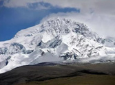
Shishapangma:
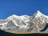
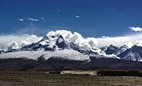
Mount Everest:

Rongbuk Temple:
▍D7 Day Everest Nature Reserve (Rongbuk Monastery) - Gyatso La Sacred Mountain - Shigatse - Lhasa
Tight schedule. Altitude that night: 3950m (392km). Road conditions: asphalt road Accommodation: Self-care Today’s highlights: Mount Everest, Rongbuk Monastery, the famous Rongbuk Glacier, Gyatso La Holy Mountain In the morning, experience the magnificence of nature at the Everest Nature Reserve, the highest altitude in the world, Everest Base Camp, and if you are lucky enough, you can also see life-like animals The flag clouds of Mount Everest are floating like fire, and you can take photos of the majestic appearance of Mount Everest and the famous Rongbuk Glacier and Ice Tongue. On the way from Tingri to Shigatse, you will pass through Yilazi, which in Tibetan means "the golden peak where the light shines first". It is the origin of Tibetan knives and the best Tibetan knives can be bought. Here you can buy some marine fossil specimens collected by Tibetan children. Then return to Lhasa and the trip ends.
Gyatso La Sacred Mountain: