Lhasa-Xishuangbanna 10 days
▍D1: Depart from Lhasa in the morning and arrive in Bomi and check into hotel
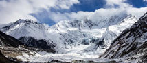
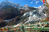
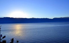
Midui Glacier: Midui Glacier is located in Midui Village, Yupu Township, about 100km east of Bomi County, Nyingchi Prefecture, Tibet. It is the most important marine glacier in Tibet and the lowest glacier in the world. It was named the most beautiful glacier in China by China National Geographic. One of the six major glaciers. The main peak of Midui Glacier is 6800m above sea level, the snow line is only 4600m above sea level, and the end is 2400m above sea level. The lower section of the glacier passes through the coniferous and broad-leaved mixed forest belt. The mountains on both sides are majestic and steep. The snow-capped mountains and clouds are intertwined together like a dream, which makes people marvel. . Climbing an iceberg requires certain physical strength. You need to bring food, water and other supplies, and pay attention to keeping warm. Midui Glacier is the most important marine glacier in Tibet and the lowest glacier in the world. It was selected as one of the six most beautiful glaciers in China by China National Geographic magazine. Midui is a place named after a glacier. It is located about 100 kilometers east of Bomi County, Nyingchi Prefecture, Tibet. Traveling among the majestic and steep mountains, the uncanny workmanship and splash-ink landscapes, the glaciers and cliffs, the snow-capped mountains and the clouds are always awe-inspiring. Midui Glacier is located in Mimei and Midui villages, Yupu Township, Bomi County, more than 90 kilometers away from Zhamu Town, where the county seat is located. The main peak of Midui Glacier is 6,800 meters above sea level, the snow line is only 4,600 meters above sea level, and the terminal end is 2,400 meters above sea level. The lower section of the glacier has passed through the mixed coniferous and broad-leaved forest belt. Transportation Midui Glacier is close to the Sichuan-Tibet Highway and is easy to access. You can charter a car to reach Midui Village in about 2 hours. From the entrance of the scenic spot to the glacier, it is about 7km away. It takes about 3 hours to walk and 20 minutes to drive to see it. Address: Yupu Township, Bomi County, Linzhi City
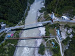
2、Tongmai Bridge:Tongmai is a place with a pleasant climate, with an altitude of only more than 1,800 meters and is located in a canyon. Abundant rain often washes away the rocks on both sides of the valley. Palong, 10 kilometers before Tongmai, is a famous natural hazard on the Sichuan-Tibet line. "When driving on the Palong Road, you are not allowed to look at the dangerous spots." This section of the Palong Canyon Road, which is only 10 kilometers long, usually takes more than three hours to pass. The Parlung Zangbo River flows through Tongmai, and its intersection with the Brahmaputra River is at the top of the famous horseshoe-shaped bend. At the beginning of 2016, the 102 landslide group of the Sichuan-Tibet Highway 318 and the section from Tongmai to Route 105 were successfully opened to traffic. The section that was once regarded as a "natural danger to Tongmai" was replaced by new roads, bridges and tunnels, and has since become a thoroughfare. Tongmai is just a small market town in Bomi County, Linzhi City, Tibet. It happens to be at the intersection of Palong Zangbo and Yigong Zangbo. The two rapid rivers meet each other in almost a straight line. After converging, they quickly go south and merge. Enter the Brahmaputra Grand Canyon. Since the opening of the Sichuan-Tibet Highway, the Tongmai section has hardly been peaceful, and it has also gained a reputation for being dangerous. Starting from Nyingchi, we pass through Lulang and over the Sejila Mountain. It starts from Dongjiu, passes through Layue, Pailong, and ends at Tongmai, which is about 30 kilometers away. On the left side of the road is a hillside mixed with large and small rocks with loose soil. On the right side is the Lulang River (called La Yuequ in Layue) and Parlong Zangbo. The road is narrow, winding, steep, and half of it is a dirt road. Some cliffs were impassable, so Bailey steel bridges had to be built on the cliffs. In July, August and September, it is extremely dangerous to drive on a rainy night. Therefore, people call this section of the road "Tongmai Natural Danger", which is a bit scary.
Midui Glacier:

Tongmai Bridge:
▍D2: Depart from Bomi in the morning and stay in Zuogong County in the evening
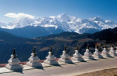
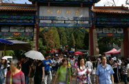
Zuogong County:It is located in southeastern Tibet, southeastern Qamdo region and the Nujiang and Lancang river basins. It covers an area of 1,726 square kilometers. The cultivated land area is 42,000 acres and the forest area is 3.92 million acres. The total population is 38,000. It has jurisdiction over 1 district, 16 townships, and 160 village committees. Zuogong means "plowing on the back of an ox" in Tibetan language. On April 30, 1959, Zuogong Zong was changed to Zuogong County, and on May 17 of the same year, the Zuogong County People's Government was established. In 1967, the county resident moved from Yazhong Village to Wangda. The county is located in the southern section of Taniantaweng Mountain and Bossula Ridge, both of which are high mountain and canyon areas in southeastern Tibet. The terrain is high in the north and low in the south, with an average altitude of about 3,700 meters. The highest altitude is 5,434 meters. It belongs to the temperate semi-arid climate zone of the southeastern Tibet Plateau. The annual temperature difference is small, the climate is dry and cold in winter and spring, and the annual frost-free period is about 90 days. Precipitation is concentrated in summer, with the annual precipitation being 405.5 mm. Common natural disasters include floods, landslides, mudslides, drought, hail, frost, etc. Proven minerals include iron, tin, gold, silver, coal, sulfur, graphite, etc. Wild animal resources include wild oxen, leopards, bears, marmots, Tibetan snow chickens, etc. Medicinal material resources include Fritillaria, Anemarrhena, Deer Antler, Kangxiang, Bear Gallbladder, Coptis Rhizoma, Panax Notoginseng, etc. Economic forests mainly include walnuts, apples, peppers, wild pears, manuscripts, dates, etc. Zuogong County is mainly based on agriculture, with both animal husbandry and forestry. The main crops include green trees, winter wheat, spring wheat, corn, sorghum, peas, rapeseed, etc. Mainly raising cattle, cattle, cattle, horses, sheep, goats, etc.; forest wood storage volume is 22.72 million cubic meters. The main tree species include spruce, fir, masson pine, cypress, etc. Economic forest resources are also very rich. There are 2 existing power stations. The installed capacity is 510 kilowatts and the annual power generation is 480,000 kilowatt hours. Handicraft products such as facade pull tabs and hidden knives have won awards at Hong Kong trade fairs. The Sichuan-Tibet Southern Highway runs through 3 townships and 53 villages in this county, with a length of 160 kilometers. It can connect to Bayi Town, Lhasa, Qamdo, Chengdu in Sichuan, Kunming in Yunnan and other places. There are also 4 branch lines with a traffic mileage of 192 kilometers. With the development of transportation industry, it has effectively promoted the development of agriculture and animal husbandry and foreign economic and cultural exchanges. Famous local products mainly include potatoes, green oil, garlic, Tibetan knife, matsutake, cordyceps, fritillary, velvet antler and plateau livestock products. Wangda covers an area of 2.666 million square meters and has a construction area of 7,259 square meters. The problems of lighting, electricity and drinking water have been basically solved. Meili Snow Mountain is a natural scenic area and is regarded as a sacred mountain by local farmers and herdsmen. There is an endless stream of believers who come to worship Buddha every year.
▍D3: Depart from Zuogong in the morning to Nanning (Yanjing) and stay at Yanjing Hotel in the evening
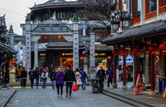
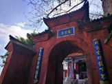
Yanjing County:It is located in the eastern part of the Tibet Autonomous Region and the southeastern part of the Qamdo region, with the Hengduan Mountains and the Tranquility Mountains running from north to south. It has the Jinsha River to the east and the Lancang River to the west. It is rich in natural resources and now has a Yanjing Nature Reserve. In 1983, it was established as a county with the approval of the State Council. Not actually established. On September 21, 1999, the Ministry of Civil Affairs issued a reply [Minfa No. 54], agreeing to abolish Yanjing County.
▍D4: Depart from Nanning Yanjing in the morning to Kawagabu and check into the hotel in Kawagabu in the evening
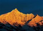
Meili Snow Mountain:It is a Dulong language, meaning a tall snow-capped mountain. The Tibetan people call it "Jia Yi Meng Qi Bu". It is the first of the ten sacred mountains in Bingzhongluo, Nujiang River. "Gawakapu" peak is the highest peak of Gaoligong Mountain, the watershed of Nujiang River and Dulong River, with an altitude of 5128 meters. There is a second peak with an altitude of 5060 meters 400 meters to the west of the main peak. The east and south sides are steep cliffs.
There are six smaller valleys and hanging glaciers developed around the "Gawakapu" peak. A larger valley glacier on the northwest side under the main peak is 2 kilometers long and extends to an altitude of 4,100 meters. The height difference between the "Gawakapu" snow mountain and the valley is as high as 3,500 meters. It is a deep-cut extremely high mountain landform. The peak walls are severely weathered and there are large areas of alpine flowstone beach terrain. In the past, large-scale valley glaciers developed in the valleys between the peaks. What remains now are only some U-shaped valleys, cirques, sheep's back rocks, blade ridges, horn peaks and other ancient glacier relics.
Below an altitude of 4,000 meters, there are original mid-mountain wet evergreen broad-leaved forests, temperate and cold-temperate coniferous forests, and the areas where various rare animals inhabit them.
Climate conditions:
There is a lot of snow during the period from January to May. Although there are no glaciers on the route, there is still the possibility of avalanches. During this period, the temperature in the mountains is relatively low, reaching more than ten degrees below zero. There is a high chance of strong winds and it is not suitable for climbing. January to March and June to September are the rainy seasons, and the fog is often thick, making it impossible to see the route clearly.
Meili Snow Mountain:
▍D5: Depart from Diqing, Yunnan to Shangri-La in the morning and check into hotel in Shangri-La in the evening
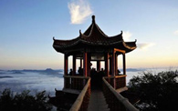
Feilai Temple is a temple located along the Yunnan-Tibet Highway 8 kilometers away from Deqin County in Yunnan Province. It was first built in the 42nd year of Wanli in the Ming Dynasty (1614 AD) and has a history of nearly 407 years. The buildings of Feilai Temple are scattered in height, and the halls and houses echo each other. The whole temple is composed of Zisun Hall, Guansheng Hall, Haichao Hall, two wings, two ears, and four side halls. The arrangement in the temple has the characteristics of the integration of three religions.
▍D6: Depart from Shangri-La in the morning to Lijiang and check into a Lijiang hotel in the evening
We went to the Dianchi Lake in Kunming to see red-billed gulls, the Erhai Lake in Cangshan Mountain in Dali, took an open-top jeep tour around the Erhai Lake, Lijiang Lashihai Wetland Park, Shuhe Ancient Town, Jade Dragon Snow Mountain and other scenic spots. Because we wanted to travel for leisure, we didn’t let Apeng arrange it. There are many attractions, but only go to particularly classic places. The past few days have been relaxing and enjoyable, and none of my previous trips were as impressive as this one.
▍D7: Depart from Lijiang in the morning to Dali and stay at a Dali hotel in the evening
1. Erhai Lake
Erhai Lake is a beautiful plateau lake with a long and narrow shape, 40 kilometers long from north to south, and an area of about 240 square kilometers. In Tuanshan, the southernmost tip of Erhai Lake, there is an Erhai Park, which is a good place to enjoy the scenery of Cangshan and Erhai Lake.
Transportation: Take Line 8 from the train station and get off at Dali Dongmen Station. Erhai Lake can be reached on foot from Dali Ancient City, or you can take bus No. 2 to Caicun Pier, or take a taxi.
Ticket: 10 yuan
Features: The location of "Erhai Moon", one of Dali's "Erhai Moon", is shaped like an ear and named "Erhai". It is known as the "Pearl of the Plateau".
Travel tip: Rent a bicycle or motorcycle in the ancient city and ride around the Erhai Lake according to your physical strength. The scenery is breathtaking.
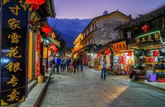
2. Dali Ancient City
The history of the ancient city of Dali can be traced back to the Tianbao period of the Tang Dynasty, when Nanzhao Wanggeluofeng built Yangjume City (near the three west pagodas of the present city) as its new capital. The current ancient city was built in the 15th year of Hongwu in the Ming Dynasty (AD 1382). There is a moat outside the city, surrounded by walls, with a gate each in the east, west, south and north, all with towers, and turrets at the four corners.
Tour time: half day
Transportation: Ride back to the ancient city and take a stroll in the ancient city.
Erhai Lake:
Dali Ancient City:
▍D8: Depart from Dali to Kunming in the morning and check into Kunming hotel in the evening
1. Xishan Park:Xishan is located on the west bank of Dianchi Lake, also known as Biji Mountain. It was the first of the "Eight Scenic Spots in Southern Yunnan" in the Yuan Dynasty and the first of the "Four Famous Mountains of Yunnan" in the Ming Dynasty. Looking from afar, Xishan looks like a woman lying on the shore of Dianchi Lake, known as the "Sleeping Beauty of Xishan". The forest here is dense, the environment is fresh and elegant, and you can overlook the vast Dianchi Lake. It has always been a good place for Kunming people and tourists to climb mountains and enjoy the scenery. The Longmen Grottoes on the mountain are even more ancient and precious, and are a must-see for tourists who love humanity.
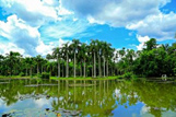
2. Dianchi Lake:Dianchi Lake is also known as Kunming Lake, Kunming Pool, Diannan Lake and Dianhai Lake. This is also the first beautiful place worth visiting. Of course you must visit here on your first day in Kunming. Kunming Lake is also the largest freshwater lake in Kunming. To reach this attraction, you only need to take a city bus. No tickets are required. It can be said to be a very cost-effective attraction.
3. Green Lake Park:Cuihu Park is the largest park in Kunming. It is also a very beautiful park and is known as the beautiful jade in the city. There are two embankments in the park, which divide the park into 5 scenic spots. Each scenic spot can enjoy different scenery. The scenery of the island in the middle of the lake is particularly intoxicating. In the evening, you can sit in a small cafe for a while, then go outside the park to have a simple dinner and enjoy the night view. The scenery of this park is even more beautiful during the day, with light clouds and gentle wind in the sky and blue water. At night, the stars are reflected in the water of the lake, and the scenery is not bad.
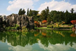
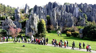
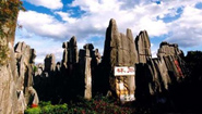
4. Stone Forest Scenic Area:It has the longest history of karst landform evolution in the world, the widest distribution area, complete types and unique shapes of the Paleozoic karst landform community stone forest, which is known as "the first wonder in the world". Shilin Yi Autonomous County, formerly known as Lunan Yi Autonomous County, is a suburban county in Kunming City, Yunnan Province, 78 kilometers away from Kunming. Shilin is the hometown of Ashima in China. The Yi culture represented by Ashima is rich in connotation and has far-reaching influence.
5. Kunming World Expo Park:The Expo Park is the exhibition base of the Kunming World Horticultural Expo. It is located in the northeastern suburbs of Kunming, 6 kilometers away from the city, and brings together horticultural achievements from all over the world. The park mainly includes five major exhibition halls: China Pavilion, International Pavilion, Human and Nature Pavilion, Science and Technology Museum, and Greenhouse; six thematic exhibition gardens: Bamboo Garden, Vegetable and Fruit Garden, Herb Garden, Bonsai Garden, Arboretum Garden, and Tea Garden; Three major outdoor exhibition areas: domestic outdoor exhibition area, international outdoor exhibition area, and corporate outdoor exhibition area, form a large-scale and magnificent international park. The architectural art and sculpture art in the park are integrated, coupled with various precious plants and flowers from various countries inside and outside the park, the decoration of flowers makes the Expo garden colorful, dazzling and more complete, fully reflecting the harmonious development of man and nature. this theme.
Xishan Park:
Dianchi Lake:

Green Lake Park:

Stone Forest Scenic Area:
▍D9: Arrive from Kunming to Xishuangbanna in the morning and stay in Xishuangbanna in the evening
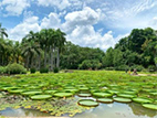
Xishuangbanna Tropical Botanical Garden:Located in the tropical forest sea of Menglun Town, Mengla County, Xishuangbanna, the locals call it Menglun Botanical Garden. The park is divided into two parts: the east area and the west area. The main attraction is in the west area, which is composed of several small botanical gardens; the east area is a narrow tropical rain forest suitable for hiking. There is a long distance between the east and west areas, and the scenic area is connected by battery cars.
There are more than 20 specialized botanical gardens in the West District. The most popular among tourists is the "Exotic Flower Garden", which has flowers that change colors, clock flowers that bloom on time, dancing grass that trembles with music, and tree trunks that do not grow. The various exotic flowers and plants, such as the bachelor tree with green leaves and the curare tree that seals its throat with blood, are an eye-opener.
The East District is a large area of pristine tropical rainforest, where you can see large areas of wild orchids, strangler trees and other wonders. Scenic trails are paved in most areas of the forest, so please pay attention to protecting the plants.
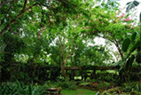
Manting Park:Located in the southeast of Jinghong City, Yunnan Province, it is a natural village-style park and a city park with a long history in Xishuangbanna. In Manting Park, travelers can go to the vine area and peacock garden to see the flora and fauna, visit the charming Dai and Thai-style buildings, and watch ethnic minority song and dance performances at night.
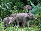
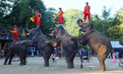
Wild Elephant Valley:It is located 1km north of Jinghong City in Xishuangbanna and on the west side of National Highway 213. This is a place frequented by Asian wild elephants, hence the name Wild Elephant Valley. When you come to Wild Elephant Valley, you can watch elephant performances and see the tropical rainforest. There are more than 4,000 meters of walking trails in the scenic area that wind through the tropical rainforest. You can walk along it and feel the atmosphere of the tropical rainforest. Not only can you see rare tropical plants on both sides of the trail, but you can also see wild elephants. footprints, feces and other traces. If you are lucky, you may even see a herd of wild elephants roaming in the forest.
There are fixed elephant performances every day near the south gate of the scenic spot. The naive elephants interact with the staff and can dance, cross the single-plank bridge, and even kick a ball with their trunks, which is very exciting. Here, having close contact with well-trained elephants is safe, fun and a great experience.
There is also a bird garden and butterfly garden near the south gate that can be visited together. There is an elevated corridor about 920 meters long from the Aviary to the North Gate Asian Elephant Museum. You can see elephant skeleton specimens and learn about elephants. The scenery along the way is also very good.
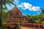
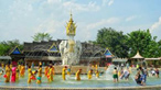
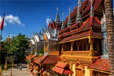
Xishuangbanna Dai Garden:Menghan Town is located in the southeast of Jinghong City. The Dai Garden consists of five well-preserved natural Dai villages, namely Manjiang, Manchunman, Manting, Mancha and Manga. No matter which village you walk into, you will see typical Burmese pagodas and traditional Dai bamboo buildings, and feel the rich Dai culture.
Entering the gate of the scenic spot, you will first see the welcome square, where the enthusiastic Dai people will dance the welcome dance, sing congratulatory speeches, and sprinkle water blessings. Then we came to the Manchunman Ancient Buddhist Temple, which is one of the oldest Buddhist temples in Xishuangbanna with a history of more than 1,400 years. When you enter the temple, you can worship Buddha and pray amidst the loud chanting of sutras.
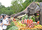
The most solemn festival for the Dai people in Xishuangbanna is the Water Splashing Festival. You can feel this lively scene at the Water Splashing Square in the Dai Garden. "Every day is the Water Splashing Festival" here. Hundreds of people gather at the pool, splashing water on each other to wash away the dust and sins. Remember to bring a change of clothes.
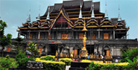
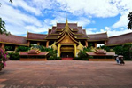
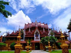
Xishuangbanna Buddhist Temple:The temple is located near Manting Park in Jinghong Town. It is the center of worship for Buddhist believers in Xishuangbanna, and there is an endless stream of believers coming here to worship. The architecture of the Zongfo Temple is majestic and unique. Every corner is different. The beautifully carved beams and columns are a joy to look at. Xishuangbanna Zongfo Temple and Manting Park are connected, and tourists generally enter the Zongfo Temple from Manting Park. Visitors can first admire the exquisite and majestic buildings outside. If they have time, they can go inside the temple, receive Buddhist baptism, relax themselves quietly, and listen to the sounds of nature. The main Buddhist temple is called "Wabajie" in Dai language. It is the center where Buddhist believers in Xishuangbanna go. Before liberation, it was a famous place for high rulers and chieftains in Xishuangbanna to pray for blessings. It is also a higher-level Buddhist temple in Xishuangbanna.
Tropical Botanical Garden:
Manting Park:
Wild Elephant Valley:
Dai Garden:
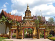
Main Buddhist temple:
▍The 10-day trip is over. (drop off)