Classic 9-day tour to Lhasa-Chengdu
▍Day 1: Lhasa - Bayi, driving: 426+(Basongcuo) 84km, accommodation: Bayi [elevation 2985 meters]
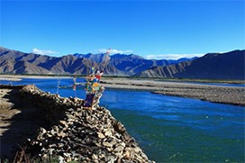
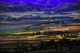
Departing from Lhasa in Chengdu on the first day, we passed through the Lhasa River and enjoyed the scenery of the Lhasa River. Three hours later we arrived at Mira Pass. Mira Mountain is 5,021 meters above sea level. After descending the mountain, we reached Bangjietang Grassland. Continuing on from the Dabangjietang Grassland, you will reach the Niyang River. You can enjoy the natural scenery of the Niyang River along the way. On the way, you can visit Basongcuo Lake on the 84 kilometers of National Highway 318. It is up to you to decide whether to go to Basongcuo. Along the way, you can enjoy the scenery of the Niyang River Valley and the dense virgin forest, allowing you to feel the beautiful scenery of the Niyang River. Accompanied by the Niyang River, you will arrive at Bayi Town, Nyingchi City.
▍The next day: August 1st - Bomi, driving: 245km, accommodation: Bomi [elevation 2750 meters]
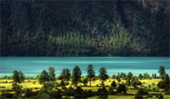
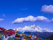
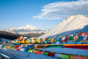
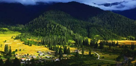
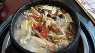
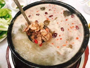
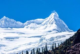
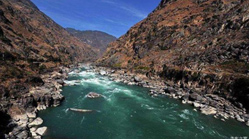
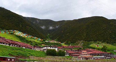
The most famous scenic spot in Linzhi is the Great Turn of the Brahmaputra River. It takes a day to go there. The Great Turn of the Brahmaputra River is 160 kilometers away from Nyingchi. There is another small scenic spot called Cypress King. The cypress trees here are 2,500 years old. The ticket to Cypress King attraction is 30 yuan per person, you decide whether to go or not. Travel 29 kilometers and cross Sejila Mountain, with an altitude of 4711 meters. Don’t forget to look at Namjagbarwa Peak from the top of the mountain. Namjagbarwa Peak is the intersection of the Himalayas, the Tanggula Mountains and the Hengduan Mountains. It is the second highest mountain in the Tibet Autonomous Region of China, the Himalayas, with an altitude of 7791 meters, located in the eastern Himalayas. It is also the second highest mountain that can be viewed when renting a car from Lhasa and returning to Chengdu. After slowly going down the mountain, you pass through the Lulang Forest Sea and arrive at the Lulang Alpine Ranch Town surrounded by virgin forests. The current construction is a European-style town. For lunch, you can taste the famous stone pot chicken in Lulang Town. The ingredients of stone pot chicken include palm ginseng, cordyceps, angelica, and other local traditional Chinese medicine ingredients. The formula is relatively scientific. After lunch, we continued on our way through the intersection of the Parung Zangbo River and the Yigong Zangbo River, which is Pailong. Pailong is also a small town called Pailong Menba Nationality Township. You may not be able to see the Tongmai Natural Barrier and Tongmai Natural Barrier in the past, because now you go directly through the tunnel without going through Pailong and Tongmai Natural Barrier. Isn’t it a great pity? Two years ago, the Pailong and Tongmai natural dangers were the most experienced on the Sichuan-Tibet line. How difficult and dangerous the Sichuan-Tibet highway is. Travel two hours to Jinguxiang Lake to reach Bomi.
▍Day 3: Bomi-Ranwu, driving: 129+16km, accommodation: Ranwu Lake [elevation 3960 meters]
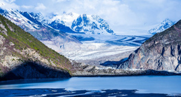
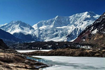
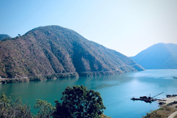
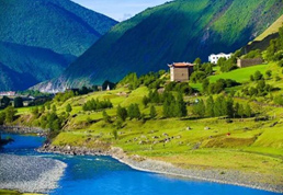
After getting up early, we will visit the Midui Glacier, the most beautiful glacier in China. It is 100 kilometers from Bomi to the corner of National Highway 318 at Midui Glacier. I don’t know what language to use to describe this small village at the foot of the mountain. Use whatever language you want to express it when you see it with your own eyes. You can walk or ride horses on Midui Glacier. Visit Midui Glacier and go down the mountain to Ranwu (36 kilometers). Ranwu Lake is the main source of Palong Zangbo, a tributary of the Brahmaputra River. There are two water sources of Laigu Glacier in the north. The reason is that Ranwu Lake always has abundant water resources. Ranwu Lake is surrounded by green pastures and green crops; there are vast forests on the mountainside beside the lake.
▍Day 4: Ranwu-Zogong, driving: 291km, overnight: Zuogong [elevation 3810 meters]
Depart from Ranwu early in the morning and arrive at Basu County. Before Basu County, we pass through Bangda, the intersection of the Sichuan-Tibet Southern Line and the Northern Line. The only airport in eastern Tibet is built on the open Bangda grassland. It connects to Qamdo in the north, Chengdu in the east, and Lhasa in the west. It is an important north-south transportation hub in Tibet. Cross the biggest natural danger in the Hengduan Mountains - the Nujiang Mountain Pass, and reach the famous Ninety-Nine Road Turns down to the Nujiang River, with an altitude of 4841 meters. Then cross Dongda Mountain to Mangkang.
▍Day 5: Zuogong-Batang, driving: 253km, accommodation: Batang [elevation 2909 meters]
Starting from Zuogong, it is 160 kilometers to Mangkang. This 160 kilometers is the most difficult road to walk. You will feel that there are endless turns and mountains. After that, you will pass through Mangkang County, which is the last road in Tibet. In the county town, you will pass through the Lancang River and the Nu River. Then cross the Jinsha River Bridge into Sichuan Province. After 30 kilometers, we arrived at Batang County, which is rich in apples and walnuts and is the first county town in Sichuan. We stayed in Batang for the night.
▍Day 6: Batang-Daocheng, driving: 332 km, accommodation: Daocheng [elevation 3750 meters]
After breakfast, rent a car from Lhasa to Chengdu. Why go to Daocheng Aden? Because Daocheng Aden is only 300 kilometers away from the 318 National Highway, so there is no regret if you turn a corner. If you make a special trip from Chengdu to Daocheng Yading, the round trip is more than 2,000 kilometers. So just rent a car from Lhasa and go back to Chengdu via Daocheng Aden. Take in the natural scenery of Batang and climb over Haizi Mountain. You can take photos here as a sister lake of Haizi Mountain and Yakou, which you often see online. Along the way down the mountain, we pass through Haizishan Nature Reserve and the beautiful and vast Maoya Prairie. Maoya Prairie is located to the west of Litang County. In the embrace of mountains, the grassland is as lush as the sea. In summer, under the clear blue sky, there are herds of cattle and sheep, the green grass is endless, and the wild flowers are in full bloom, and you are covered with the fragrance of flowers when you roll around; in autumn, the clear sky is high, the clouds are white, and the grass and trees are golden. Continue forward to the world's tallest city, Litang, pass by the west gate of Litang, turn right and get off National Highway 31, heading towards Daocheng. Head to Daocheng and climb over Rabbit Mountain, the legendary tortoise and hare race, pass by the largest ancient glacier site on the Qinghai-Tibet Plateau and the Daocheng Ancient Ice Cap - Haizishan Nature Reserve (4,500 meters above sea level), and arrive at Shambhala - Daocheng. It is not recommended to live in Daocheng. You have to work hard for two hours. It is best to live in Shangri-La Township. The altitude there is only 2,900 meters. It is a very beautiful small village. Because the altitude of Daocheng County is a bit high, it is not good for your rest and sleep.
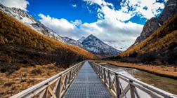
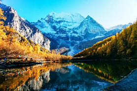
▍Day 7: Daocheng-Aden, driving: 160 km, accommodation: Aden [elevation 3900 meters]
If you live in Shangri-La Township and head to Yading Nature Reserve early on the second day, (Dading Village) is only 78 kilometers away. If you get up early, you can enter the Aden Nature Reserve on the same day and visit the Aden Scenic Area throughout the day. You can decide whether to go to Milk Sea according to your physical strength and actual situation. The altitude there is 5,200 meters, which is a test of your perseverance and physical strength.
▍Day 8: Aden-Daocheng, driving: 160 km, accommodation: Daocheng [elevation 3750 meters]
If you arrive at the Aden Scenic Area in advance on this day, you can shorten one day. If you are not satisfied, then continue to enter the Aden Scenic Area on the second day and indulge in the dreamland. Say goodbye to the three holy mountains, step by step away from the last Shangri-La - Aden, go to Daocheng to check in, and bathe in Rubchaka Hot Spring. Tips for the day: The climate in Aden scenic area is unpredictable, please bring rainy season and gloves, and you need to pay attention to safety when riding horses. You must be Only when the groom leads you can you ride.
▍Day 9: Daocheng--Xinduqiao, driving: 359 km, accommodation: Xinduqiao [elevation 3460 meters]
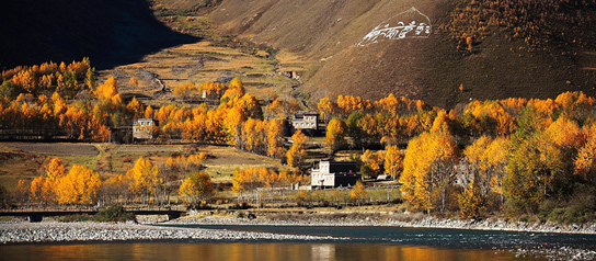
The small town of Xinduqiao is a town that we often call a photography paradise. The small streams and poplar trees add autumn colors. The scenery on both sides of the road is not what it was originally. Due to a large amount of development, the beautiful scenery on both sides of the road has disappeared. Only a few kilometers away by car, the small town of Xinduqiao is still so beautiful and spectacular. If you like to take pictures, you must get up early, and you will definitely get great surprises and rewards.
▍Day 10: Chengdu - Return to Lhasa, end of trip.
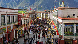
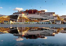
Lhasa:
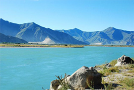
Lhasa River:
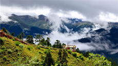
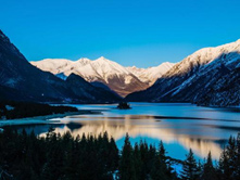
Basongcuo:
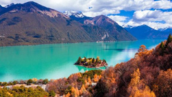
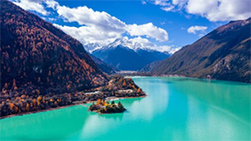
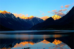
Four Seasons Lashan:
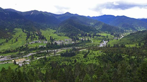
Lulang Linhai:
Lulang Special Stone Pot Chicken:
Midui Glacier:
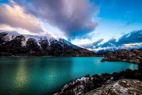
Ranwu Lake:
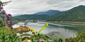
Lancang River:
Batang:
Daocheng:
Xinduqiao:
Chengdu: