Twelve days tour
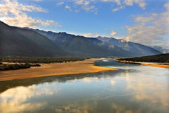
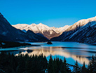
▍Day 1: Arrive at Daling Zhimilin Airport. The driver and tour guide of Satuo Travel will present you with a white hada. Then go to the hotel, enjoy the Niyang River along the way, and go to Benri Shenshan (4500m) for viewing and enter Linzhi City, Wanqingtang Hotel rests and adapts.
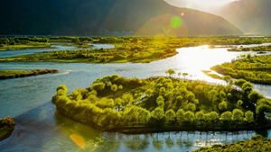
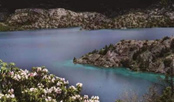
Niyang River is the "mother river" in Gongbu area of Tibet Autonomous Region, also known as "Niangqu", which means "tears of the goddess" in Tibetan. The vegetation along both sides of the Niyang River is intact, the scenery is beautiful, the scenery is charming, and it passes through many scenic spots. It is one of the rivers on the Qinghai-Tibet Plateau. There are many wild birds in the Niyang River Scenic Area, which is also a famous wintering area for black-necked cranes in Tibet.
lie inLinzhi CountyTo the southeast of where the camp is generally located,Brahmaputra RiverGongbo area on the north side. The mountain isbenbojiaoIt is one of the important sacred mountains worshiped by believers. The believers place all their hopes for happiness in this world and liberation in the next life on Benri Sacred Mountain. In order to eliminate sin obstacles and various diseases, they circle the mountain on time every year. It is recognized in all Tibetan historical records that Benri Sacred Mountain is the only mountain in the world that was personally visited by Buddha Dunba Xinrao.blessingThe sacred mountain. Because this mountain is surrounded byFortunately, Miwo Tathagata BuddhaIt is a sacred mountain that has been blessed, so it is still valued and worshiped. Circling Benri Mountain is also an ideal for many believers around the world.
▍Day 2: Head to Sejinla Mountain from Linzhi City, visit Namjagbarwa Peak, and stay at Lulang Pearl River International Hotel. (elevation 3700m)
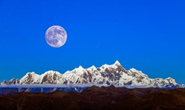
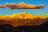
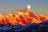
Namjagbarwa Peak, located in theHimalayas、The intersection of the Nyenchen Tanglha Mountains and the Hengduan Mountains is the Lingchi City in the Tibet Autonomous Region of ChinaThe highest mountain, with an altitude of 7782 meters, belongs to the Himalayas and is located at the easternmost end of the Himalayas.It is the holy land of Tibet’s oldest Buddhist "Yongzhong Benjiao" and is known as the "Father of the Mountains in Tibet". At the same time, the adjacent Yarlung Zangbo Grand Canyon turned a horseshoe-shaped bend around him, and then extended out toward the Indian Ocean. Namjagbarwa Peak is also known as "Muzhuobar Mountain". Its huge triangular peak is covered with snow all year round and shrouded in clouds and mist. It never reveals its true face easily, so it is also called the "Shameful Girl Peak". Namjagbarwa has many explanations in Tibetan, one is "thunder and lightning burning like fire", the other is "spear piercing the sky", and the other is "stone falling from Tianshan Mountain". The latter name comes from the "Battle of Menling" in "The Biography of King Gesar", in which Namjagbarwa Peak is described as "shaped like a spear, piercing the sky."
▍Day 3: Visit the small town of Lulang. In the afternoon, you can visit Lulang Forest Sea. For dinner, choose the local specialty stone pot chicken.
Lulang is located on the Sichuan-Tibet Road about 80 kilometers east of Bayi Town in Linzhi, Tibet. It has an advantageous geographical location and rich tourism resources, and is known as the "Switzerland of the East". It is mainly dominated by glacial landforms, mountain canyons and animal and plant resource landscapes. It is a rare top tourist resource place in the world where glaciers, mountains, canyons, meadows, forests, rivers, lakes and other landscapes coexist.
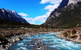
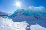
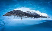
▍Day 4: Go to Ranwu Town (3927m), admire Laigu Glacier, check into Phuntsok Kangsang Hotel, and rest
Laigu Glacier is the collective name for a group of glaciers located in Basu County, Chamdo region of Tibet. Wuzhen, close to Ranwu Lake, is the source of Palong Zangbo. Ice and snow meltwater flows into Ranwu Lake, the lakeside is dense virgin forest, and there are many primitive Tibetan villages, including Meixi, Yalong, Ruojiao, Dongga, Xiongjia and Niuma glaciers, among which the Yalong Glacier is the most spectacular. The "Yalong Glacier" is 12 kilometers long, extending from the main peak of Gangrigabu Mountain at an altitude of 6,606 meters to Gangrigabu Lake at an altitude of 4,000 meters; climatically, it is located in the Indian Ocean monsoon directionThe Qinghai-Tibet Plateau is the main channel for transporting cold air. It has sufficient rainfall and is conducive to the development of glaciers. It is a marine glacier.
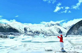
▍Day 5: After breakfast, walk around Ranwu Lake. Afterwards, head to Basu County (elevation 3260). Upon arrival, check into Bangda Maoge Hotel and rest.
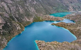
The melted water from the snowy mountains surrounding Ranwu Lake forms the main water supply source for Ranwu Lake. It is the main source of the famous Palong Zangbo River.
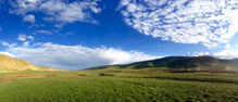
▍Day 6: Depart from Basu County, visit Bangda Grassland along the way, pass through the 72nd bend of the Nu River, pass through Luolong County, arrive at Bianba County (3700m above sea level), and stay at Luolong Zhuoyue Hotel店
From Chamdo Town go south along the Lancang River, then turn into Wengou on the west side and go up, about Arrive at the famous Bangda Grassland in about 3 hours. The altitude here is about 4200 meters, which is the watershed between the Lancang River and the Nujiang River - Tannianta WengshanA wide Tanshan source basin on the main ridge, with the upper reaches of the Yuqu River on the east branch of the Nujiang River meandering in between, and the vast low-humid shoals on both sides of the river with dense growth Low-growing Da SongMeadow Plant. Bangda Grassland is more than 80 kilometers long and about 20 kilometers wide. The terrain is flat and the grassland is fertile. Bangda is also a transportation hub in eastern Tibet. The world's highest airport, Bangda Airport, is located on the grassland north of Bangda. It was completed and opened in 1995. Sichuan-Tibet Highway The northern line and the southern line also meet again, going north through Qamdo and Jiangda to Lhasa, and going south through Mangkang entered Sichuan.
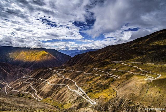
"Nujiang 72 Turn": refers to Yela Mountain at the upper pass of the Sichuan-Tibet Line with an altitude of 4,618 meters. span>Panshan Highway (located on the South Sichuan-Tibet Highway, that is, the Southern Line of Sichuan-Tibet Highway span style="color: #00B0F0;">Bangda Town to Basu County, 16 kilometers) in the Qamdo region of TibetBasu County, passing through the Nujiang River on the way, the steep slopes and dangerous roads are known as the "Ninety-nine Roads" "Huitou Bend", Yela Mountain's "108 Turns", and "Sichuan-Tibet 99 Bends". According to some statistics, there are actually more than 130 bends.
▍Day 7: Depart from Bianba County, visit Sanse Lake (elevation 4100m) on the way, return to Bianba County (elevation 3705m) and go to Bi County. Check into No.1 Hotel
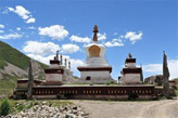
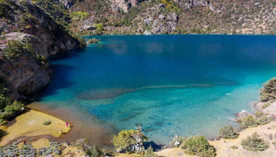
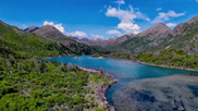
Bianba County in Qamdo Prefecture, Tibet, there is an autonomous region-level scenic spot "Three Color Lake" in Puyu Village. "Three Color Lake" is also known as "Puyu Three Color Lake" "Puyu Sanse Lake is located in the subsidence zone of the Nujiang Canyon fault, with complex terrain and changeable climate. The lake area is surrounded by snow-capped mountains. The mountains are steep and winding. The vegetation on the slopes is vertically distributed, and the snow on the mountain tops does not melt all year round. The "Three Color Lakes" are Black Lake, White Lake and Yellow Lake. They have different colors under the sun, so they are called "Three Color Lakes". The three-color lakes are arranged in irregular "pin" rows. The lakes are separated by low mountain platforms. They are all formed by years of ice and snow accumulation in the low-lying areas of the valleys. The three lakes have a total area of about 150,000 square meters and a water storage capacity of 2.8 million square meters. Among them, Black Lake is the largest, with an area of about 100,000 square meters and a livestock water capacity of 2 million square meters.
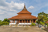
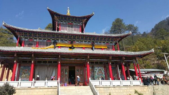
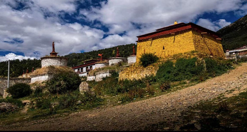
▍Day 8: Ru County (elevation 4300m), visit Bodhidharma Temple along the way. Stay at Nujiangyuan Hotel in Ru CountyDharma Temple, whose hidden name is Danpeilin, means "Garden for the Promotion of Teachings". It is one of the thirteen largest Kagyu temples in Jiangdi and is located in Pagoda, Weixi County, Yunnan Province. The Holy Mountain of Patriarch Bodhidharma in urban and rural areas was built in the first year of Kangxi (1662). On the east mountain wall of the temple, there is a stone cave where Patriarch Bodhidharma meditated. Hence the name of Bodhidharma Temple. There were originally thirteen courtyards of monks’ houses and 200 resident monks. name.
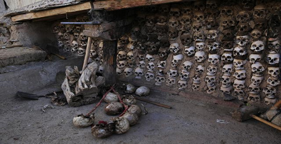
Bodhidharma Temple skull wall
Tibetans regard sky burial as the most sacred ceremony in a person's life. Under normal circumstances, no one is allowed to visit the sky burial platform. It is one of the few sky burial sites in the district that allows tourists to visit, and the skull wall is a special product of the sky burial in Dam Temple.
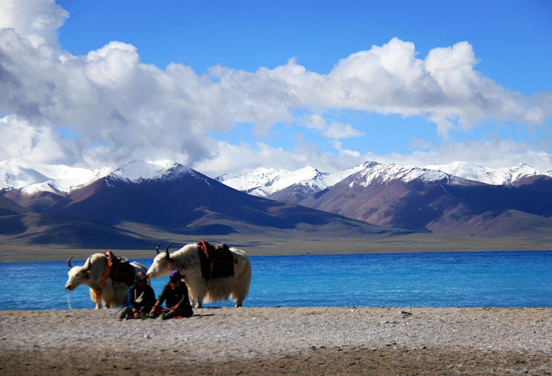
▍Day 9: Depart from Damxung County and arrive at Namtso (elevation 4718m), stay at Damxung Minshan Hot Spring Hotel
▍Day 10: After breakfast, depart from Damxung to Rezhen Temple, return to Lhasa in the afternoon, and check into Naicang Hotel.
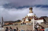
Rezhen Temple was founded in 1057 by Zhongdunpa, the founder of the "Kadam Sect". It has a history of more than 900 years. It is the first temple of the "Kadam Sect" in Tibet and is located 240 kilometers north of Lhasa. It is located in Tanggu Township, Linzhou County. According to legend, there used to be a bare mountain with no vegetation. Later, King Songtsen Gampo of Tibet visited here, sprinkled shampoo water on the hillside, and prayed for blessings, so 25,000 green cypress trees grew. "Heat Vibration" means "eradicating all worries and continuing until transcending the three realms of reincarnation."
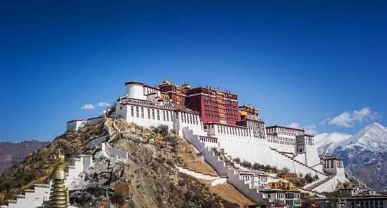
▍Day 11: Lhasa City (elevation 3650) Visit the Potala Palace, Jokhang Temple and stay at Naicang Hotel
The Potala Palace is located on Maburi Mountain in the northwest of Lhasa, the capital of the Tibet Autonomous Region of China. It is a palace-style building complex. It is said that it was built by Zampu Songtsen Gampo of the Tubo Dynasty to marry Princess Chizun and Princess Wencheng[23 ][17]; Another theory is that it was built as the royal palace after Songtsen Gampo moved the capital to Lhasa. [24] After reconstruction in the 17th century, it became the winter palace residence of the Dalai Lamas of all generations and the center of Tibetan political and religious governance. In 1961, the Potala Palace became one of the first batch of national key cultural relics protection units designated by the State Council of the People's Republic of China. In 1994, the Potala Palace was listed as a World Cultural Heritage. The main buildings of the Potala Palace are the White House and the Red Palace.
The entire palace has a Tibetan style, more than 200 meters high, with 13 floors in appearance, but only 9 floors in reality. Because it was built on the mountainside, the large stone walls stand like cliffs, making the building seem to be integrated with the hill, making it majestic.
▍Day 12: After breakfast, transfer to the airport and end of the trip
Niyang River:
Sejinla Mountain:

Namjagbarwa:
Laigu Glacier:
Ranwu Lake:

Bangda Grassland:
Three Color Lake:
Bodhidharma Temple: